Kabalega Trail TOUR

This will involve a tour of Omukama Kabalega historial sites, some of which are highlighted here below

Mparo-2

Mparo Royal Tombs

Formally Omukama Kabalega’s favourite palace in the course of his reign, Mparo royal tombs are also the burial grounds of Omukama (‘King’) Chwa II Kabalega. The tombs are situated about four kilometers from Hoima City centre, along the Hoima – Masindi highway.

img_20190611_164338_7005148452247323128971

Kabalega Falls

Kabalega Falls, believed to be the most powerful waterfall in the world is a waterfall at the apex of Lake Albert on the Victoria Nile in Uganda. At the top of Murchison Falls, the Nile forces its way through a gap in the rocks, only 7 m (23 ft) wide, and tumbles 43 m (141 ft), before flowing westward into Lake Albert. The outlet of Lake Victoria sends around 300 cubic meters per second (11,000 ft³/s) of water over the falls, squeezed into a gorge less than 10 m (33 ft) wide.)

Mpumwire-Hill

Mpumwiire (Mpumudde) Hill

Located about 2km off Kamuli Road in Jinja Municipality, Mpumwiire (Mpumuddehill is where Omukama Chwa II Kabalega met his death while making his back to his kingdom – Bunyoro kitara from Seychelles Islands where he had been exiled for 24 years. 

The local chiefs rallied people in their communities to take up and pile stones on the site of his demise. Todate, it remains a sacred site in Busoga, and where Busoga Kings are enthroned, however the site is not marked and developed.

Royal Mile Budongo-Forest1

Budongo Royal Mile

Royal Mile in Budongo Forest. It is a spectacular one-mile-long forest road that was made by Omukama Kabalega as military training ground for his Army – Abarusuura.

With great bird-watching, primate life, and scenery, Budongo Forest located in Uganda is northwest of the country on the way to Kabalega Falls, along the East African Rift Valley escarpment.


bakers-and-king-kabalega-monument-near-masindi-1872-in-uganda-copyright-rupi-mangat-800x600-1

Omukama Kabalega - Sir Samuel Baker Battle Ground

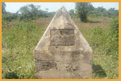
In 1872, as Governor General of Equatorial Province in South Sudan, Sir Samuel Baker in attempts to colonise Uganda project, attacked BunyoroKitara and started erecting his government headquarters in Masindi in apparent preparation to annex Bunyoro-Kitara Egypt – Equatorial Province. 

In a Battle code-named Baligota Isansa, still as a youthful newly enthroned king, Omukama Kabalega defeated and repulsed Sir Samuel Baker’s advances to annex Bunyoro.

Kikangaara Hill

Kikangaara Hill in Kibaale District, Buyanja. The place where Omukama Cwa II Kabalega was enthroned King in 1870.

Musaijamukuru Hill

Musaijamukuru Hill. Used as as Omukama Cwa II  Kabalega’s watch-tower during the Anglo-Nyoro war as atop it, it gives a vast expanse of view in all sides. 

This enabled him to know where invading forces would be approaching from to plan sufficiently.

Located along Hoima Kikuube Road, in Buhimba – Kikuube District.

Kabalega Well

Kabalega Water well. Omukama Kabalega’s water well, located at Kacungiro, Kinogozi – Kikuube District. 

The site also hosts a board game curved in a rock next to it, where Omukama Cwa II Kabalega used to play with his subjects. The board game markings in the rock are still visible to-date and locals still entertain themselves to the game here.

Katasiha Caves

Katasiha Fort Caves. An entrance to some of the Interlinked underground tunnels that Omukama Cwa II Kabalega used to evade invading forces in his guerilla warfare tactics. 

Located at Katasiha, Bujumbura, along Butyaba Road – Hoima City,

Kangai - Dokolo

Kangai – Dokolo. The Location where Omukama Cwa II Kabalega was captured, along with his compatriot – Kabaka Mwanga of Buganda by British colonial forces in 1899.

Among other sites and locations